In this week’s property Surveying blog post, we are going to be looking at boundary disputes and the procedures that a boundary surveyor will follow and adhere to in the process of surveying and resolving the matter at hand.
Boundary surveyors are called upon to provide their expertise in relation to boundary disputes and assisting their clients in locating the correct location of a boundary line that separates two or more pieces of land or properties.
Boundary surveyors will often be appointed to deal with demanding disputes or differences of opinions between property and land owners, in some cases to provide clarity on the matter, in other cases resolving the matter and ultimately putting the respective owners at ease in the knowledge the boundary dispute has been resolved.
More often than not, a boundary dispute and boundary line issues will arise when an established boundary is disrupted, moved, or misinterpreted by one of the owners whom adjoins it. This is often done without any adequate evidence, a reasoned standing, or any historic or tangible evidence based of factual indications.
The outcome of these types of issue is that boundary and neighbourly dispute arises and it is at this point that an experienced boundary surveyor is required.
So, what exactly is a Boundary Line?
A boundary is a legal line and separation which divides land, or properties.
In order for a boundary surveyor to identify and determine the correct location of the boundary line which separates land or properties, it can be somewhat of a complex matter.
For the boundary surveyor to reach a firm conclusion, it will usually involve a good range of expertise and approach which will often include both a site visit and desktop research.
On Site Inspection
When a boundary surveyor visits the site or property, they would willingly embrace any information available to them from the parties whom are in the dispute.
This will not only ensure they are well informed on the matter, but will also give them a firm background on the issue they have been tasked to resolve.
Following from the initial discussions, the boundary surveyor will then proceed to comprehensively inspect the surrounding areas of the property in question to gain a greater understanding of the layout of the demise, the lay of land and broaden their understanding of the dispute in question.
Typically, at this stage of the boundary surveyor’s on site inspection, they will be looking for both boundary and historic features such as walls, hedges, fences, original fence posts, original features or anything that would have been potentially present during the construction of the property, or as close to the setting out of the boundary as possible. These will all aid to the boundary surveyor’s assessment and conclusion of their investigation.
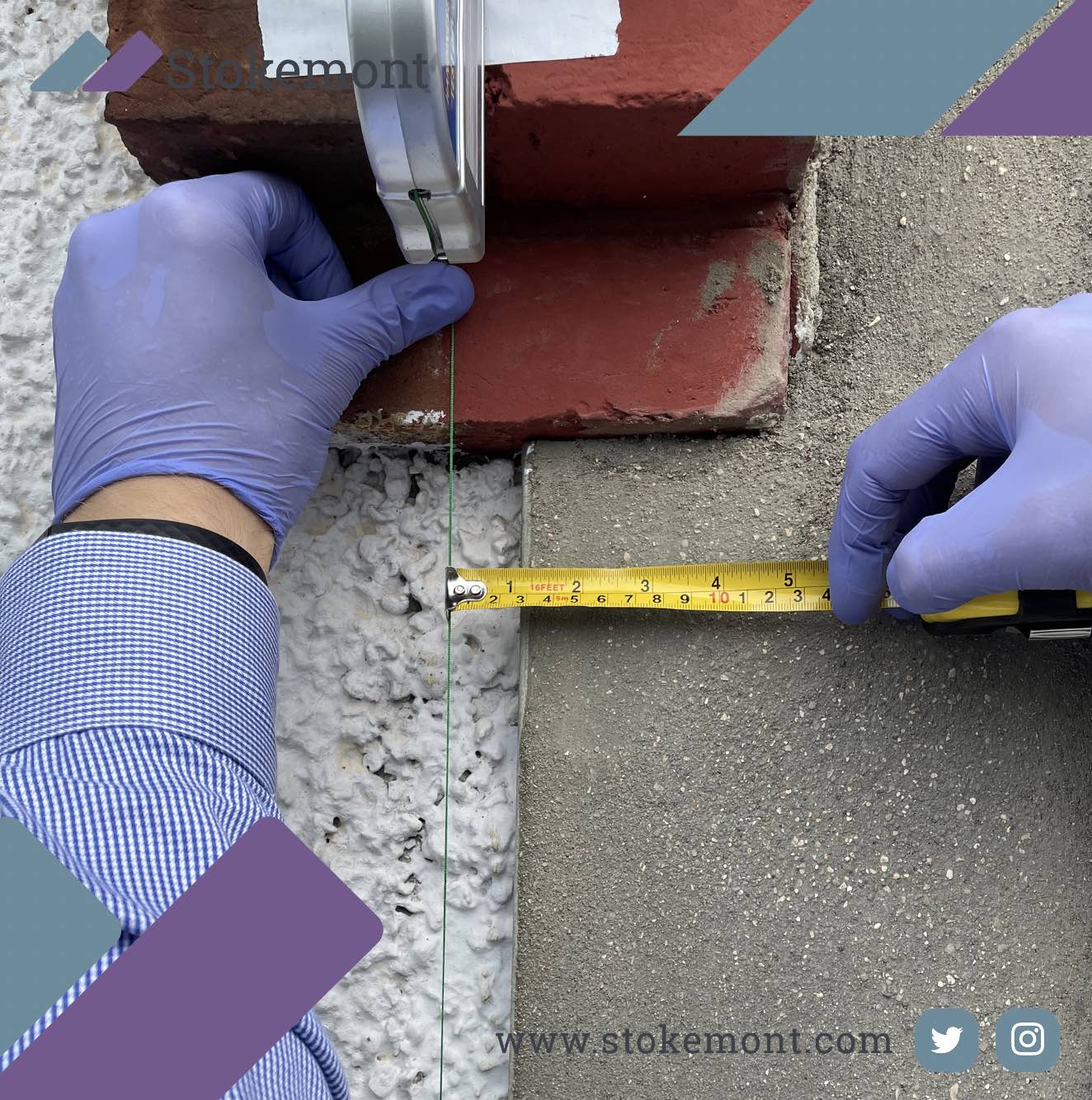
Various measurements will usually be taken on site by the boundary surveyor, as this could most likely support the findings or tone of the desktop research and or the conclusion of the matter as a whole.
Furthermore, measurements taken on site can often be very conclusive in respect of pinpointing the boundary surveyor’s firm opinion on the boundary dispute and issues at hand.
During their site inspection, boundary surveyors will often rely upon a wide variety of tools to aide in their investigation ands determination. We thought we would take a closer look at some of these.
Tape Measure
Even in the age of laser measurement, GPS pin pointing and various other technologies that are available to boundary surveyors, often the best tools are the oldest! A tape measure in an excellent example of that. It not only allows for accurate a precise measurement, it also allows for full uninterrupted use in any type of weather condition.
Ladders
Boundary Surveyors will often be up and down ladders, on and off roofs, or looking over high fences. This is all made possible by telescopic ladders allowing for the best possible vantage point on the issue at hand. Here at Stokemont, our surveyors carry 3.2 metre ladders to all inspections they attend.
Electronic Distance Laser Measure
A laser measure, will enable the boundary surveyor to accurately measure distances to within 1.5mm. An electronic distance laser measure works and operates by sending a pulse (in the form of a laser) to a specified point and then measuring the time it takes for the reflection to return, it then calculates that into distance a form.
HD 4K Camera
As with any evidence gathering mission, photography is key! Our boundary surveyors will use a camera to photograph all findings while inspecting on site. In accordance with RICS requirements, these photographs are then held on file for a minimum of 6 years.
Plum Bob
A plumb bob, is a weight with a pointed tip at its base. This weight is suspended on string connected to a cassette with a retractable pin. This allows for the cassette and plumb bob to be temporarily fixed to a wall, allowing for a vertical reference line to be set out, thereby precisely establishing a vertical datum point.
Chalk or Marking Tape
This enables and allows the boundary surveyor to identify measured positions on the property by placing a marker onto the wall thereby setting out the measured point precisely and clearly.
Boundary Surveyor’s Desktop Research
Once a boundary surveyor has completed their on-site inspection, they will then proceed with comprehensive desktop research to help further understand the boundary dispute and matters that form part of it, solidifying their professional opinion and stance.
There are several methods and resources a boundary surveyor will utilise and rely upon to formulate and reach a conclusion to their assessment on the boundary dispute.
Title Deeds
Title Deeds, or title registers are the official documents showing the chain of ownership for land or property. They can also include:
- Contracts for sale
- Wills
- Mortgages
- Leases
They will often also include references to the property and in some cases can set out key elements of information in respect of the boundary, whether that is ownership, maintenance or any other type of information.
Title Plans
The purpose of the title plan is to support the property description in the register by providing a illustrates representation and identifying the general extent of the land in a registered title. These can go a long way to help the boundary surveyor establish the background on the issue and the boundary line as intended.
Planning Records
Planning Records will help provide a back log of information regarding any changes that may have taken place to property of land. More often than not, they can also include information lending itself to boundary dispute resolution.
Sales Particulars
While these are often to low resolution or quality, none the less, they can provide a great amount of information and in many cases will pre date the current owners and dispute!
Historic Maps
This search enables the boundary surveyor to dive into the history of the property or land to assess any changes over the years and to really gauge understanding of the boundary line. In many cases there are in excess of over 20 maps that are located which gives the boundary surveyor an excellent opportunity to understand the lay of the land.
Historic Photographs
Photographs stand to be sound in the nature of it being self-explanatory and providing a snapshot of the boundary line, long before it became a dispute. They are also an excellent unbiased way for the boundary surveyor to understand the boundary position.
Boundary Surveyor Dispute Determination
Once the boundary surveyor has thoroughly reviewed all results, both the on-site findings and desktop research, they can then come to a sound conclusion on the matter and present their informed and reasoned position.
At this stage, the boundary surveyor should be able to reach a firm professional opinion on whether the current location of the boundary line is in the correct, or incorrect place and by how much, along with a detailed explanation on how the conclusion was reached.
Lastly, although very rare, it must be stated that on some occasions, the correct position of a boundary may not be able to be determined.
This would be due to there being a lack of evidence or adequate indication being available from both the site inspection and desktop research which would mean a sound professional opinion wouldn’t be possible. Here at Stokemont, we are yet to experience this issue!
If you would like to discuss boundary surveying with our team of boundary surveyors give us a call today and we will be more than happy to assist and advise you.


