In today’s Property Surveying blog post topic we are going to be discussing boundary determinations and boundary surveying.
Boundary determinations and boundary surveying disputes are one of the most typical services that we offer here at Stokemont.
Generally speaking a boundary dispute will occur when one or two owners who share a boundary have a disagreement or dispute on the position in which the boundary line is set out, the angle at which it runs, the width, thickness or placement of it.
In the first instance, here at Stokemont, we would always advise that you make a thorough attempt to resolve the dispute directly with the neighbour, however we do understand that there are situations and instances where this will simply not be possible.
If you are unlucky enough to find yourself in this position, don’t panic, you are not alone, what you will need to do is engage the services of an experienced boundary surveyor so that he or she can fully assist and help determine the matter in dispute.
One of the many resources available to a boundary surveyor when determining a dispute is the review, interpretation and measurement of scaled plans.
Scale plans are far and wide, and can range from historic maps, to Land Registry Title Plans, to construction plans, and if the property is of a newer build, it can even include the plans of the property’s footprint itself.
It is worth noting, that these plans were never intended to resolve boundary issues or disputes, and while they are indicative of the positions and layouts at which the properties should be built, in many cases they are merely an indication and do not take into account changes for peculiarities on the land itself such as differing ground levels, trees, or other forms of obstacles.
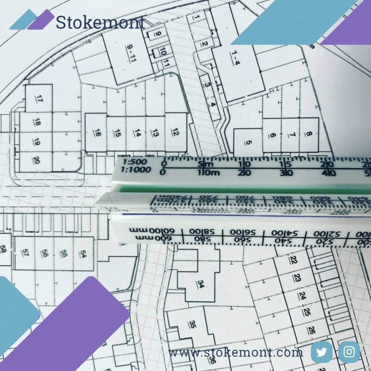
Another thing to bear in mind is that in many cases these plans are drawn at a scale which cannot assist and aid in your typical boundary dispute.
To put this in perspective, the majority of plans we have seen here at Stokemont are at a 1:1000, or 1:250 scale.
In theory, this means that every mm on the scale ruler would represent up to 1m on site.
You can therefore imagine the difficulty and inaccuracy in a surveyor attempting to draw any form of conclusion from the plans and providing information obtained through scaling them.
Many boundary disputes often circulate around widths and distances less than 1 metre, or in and around those areas.
This would mean that attempting to use the scaled plan approach would not only be inaccurate, but could actually incorrectly determine the matter resulting in an improper, or incorrect outcome.
We have included a photograph of a 1:1000 plan and a scale rule so that you can get a full understanding of this issue first hand and fully accommodate yourself with the type of obstacles that this form of investigation presents.
Instead, here at Stokemont we are very much of the opinion that a good boundary surveyor will take a considered and measured approach to all of the information they are able to find, where it is scale plans, historic investigation, or on site investigation and measurement. The very premise of a boundary surveyor’s role should be to look at all of the information they are able to ascertain and present a reasoned and considered position on the boundary that is be-fitting of the information.
Here at Stokemont we undertake numerous boundary surveys each month and pride ourselves on our thorough approach to both the on-site inspection and also the desktop research.
If you would like to discuss your boundary surveying issue or dispute with one of our experienced and qualified boundary surveyors, give us a call today and we will be more than happy to assist you.
Did you know that we also offer 30 minutes free no strings boundary surveying advice? All you need to do is get in touch with us today and our boundary surveyors will be more than happy to assist and provide some clear and concise information hopefully helping you resolve the issue at hand.


